
Amelia Soth at JSTOR Daily:
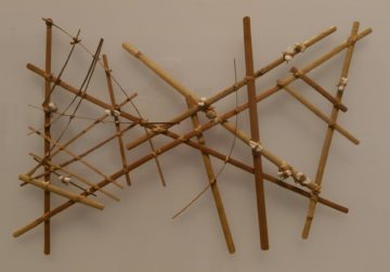 Wave charts aren’t maps so much as mnemonic devices. They’re not brought on board in order to navigate; rather, the navigator makes them as a personal reference, studying them while on land and bringing that knowledge onto the sea. There were a few different kinds: rebbelib, which represented whole island chains; meddo, which showed ocean swell patterns in a smaller area; and mattang, simple teaching tools used to diagram the basic interactions between land and sea.
While this particular mode of proprioceptive navigation was unique to the Marshall Islands, navigators throughout Micronesia and Polynesia used swells to orient themselves, along with other methods. To those who knew how to read it, the sea is full of signs: driftwood gathers at convergence zones; specific birds appear only near land; distant forests cast a greenish tint on the underbellies of the clouds above. As they traveled, songs helped to keep time, remind the sailors of important landmarks, and confer ritual protection on the voyagers.
more here.