
by Bill Murray
 Former Finnish President and Nobel laureate Martti Ahtisaari once gave a talk in our town and we went to see him. The distinguished gentleman who introduced him at Atlanta’s distinguished Piedmont Driving Club listed among Ahtisaari’s achievements “helping to achieve independence for Nambia.”
We visited Nambia a few years back, and found that the locals actually call it “Namibia.” Its European colonizers called it Southwest Africa. Call it what you like, it’s one of the world’s really remarkable places. Unusual things happen in Namibia.
Most places, rivers flow to the sea. The thousand-mile long Okavango River flows into desert, beginning in the highlands of Angola where it’s called the Cubango. The Cubango becomes the Kavango as it marks the Angola/Namibia border. There it hits a fault line and spills into the Kalahari Desert in Botswana, where it is finally known as the Okavango.
It’s hard to visualize an inland delta, so consider its scientific definition; geographers call it an alluvial fan, depositing some two million tons of sand and silt every year and draining summer rain from a catchment area something like the size of Nepal or Tunisia.
This labyrinth of channels, islands and plains brings forth papyrus swamps, forests and savannah, providing habitats for elephant, lion, crocodile, hyena, leopard, zebra, cheetah, porcupine, monkey, serval, baboon, wild dog, hippo, giraffes, buffalo, wildebeest, kudu, warthog, impala, tsessebe and countless more.
On the way from Angola, the Okavango’s variously-named waters cross a cartophile’s delight, a relic of the Europeans’ Scramble for Africa called the Caprivi Strip. A bit of background:
The Scramble was Europe’s late 19th century wholesale rush to colonize the continent. Germany came late to the Scramble and left early when it was stripped of its colonies after World War One. Its important colonies were only four, roughly today’s Togo, Cameroon and Namibia along the west coast and a region in the east centered around today’s Tanzania.
The whole way through, Chancellor Otto von Bismarck’s gut told him to hang back from Africa. He put it in plaintive realpolitik terms: “Here is Russian and here is France,” he would declare, “with Germany in the middle. That is my map of Africa.”
Torschlusspanik is one of those German compound words, literally gate-shut-panic, its origin perhaps in medieval fear of being shut outside the city gates overnight. In the Scramble, modern day Torschlusspanik caught fire in Berlin.
As other Europeans madly claimed their bits of African coast, German importers were getting blistered by their British and French rivals. Both sides of the dockyards in Hamburg and Bremen, industrialists and labor alike, prevailed on Bismarck to commission the son of a Lutheran pastor, the explorer Gustav Nachtigal, to establish German protectorates along Africa’s west coast, in Cameroon and Togoland.
 Further south, largely off European radar, Berlin granted a Bremen tobacco entrepreneur named Lüderitz protection for an exploratory base along a forbidding stretch of shoreline called the Skeleton Coast. The Skeleton Coast ran the length of today’s Namibia, between the British Cape Colony and Angola.
(Historically, the Portuguese outpaced all Europeans on a wild sprint down the coast a full 400 years before the Germans; mission after Portuguese sailing mission planted plinths, paeans to their king. But this was more exploration than conquest, more of a mad search for a way around the Cape and, for Portuguese purposes, around the trading houses in Venice and Cairo.
A notion had taken root, perhaps nothing more than a folk tale, but it pressed itself into the imagination of generations, and not just in Portugal; there was a river route across the continent, or at least to the Nile. Portuguese King João sailed caravels five hundred miles up the Senegal River; they were halted by rapids. His ships were blocked at the Barrakunda Falls on the River Gambia. These were persistent, painstaking, costly, sustained efforts in search of the presbyter Prester John, whose Christian kingdom was believed, for hundreds of years, to flourish among the Muslims and pagans, just over the horizon.)
But back to the late 19th century. In the early days of the Scramble, claiming territory for Europeans mostly meant collecting treaties with often illiterate local leaders along the coast. Dr. Nachtigal claimed Togoland and Cameroon this way in July 1884, and the German gunboat Wolf claimed Southwest Africa the next month. Down there, they put out wooden noticeboards proclaiming protection of the Reich that presumably no one could read.
Half a continent away in East Africa, meanwhile, another German clergyman’s son named Carl Peters sought to confound British interests. The recently-deposed King Mwanga of Buganda was shopping for allies to help him reclaim his throne and offering treaties first come, first served. Peters did a deal even before he could get his government’s sanction, meaning to insert a Prussian wedge between British East Africa and their territory of Sudan to the north.
For most of the nineteenth century Britain held an island called Heligoland just 25 miles off the German coast that Bismarck coveted for a naval base. And Britain needed the German bits of east Africa that Carl Peters had cobbled together. Here were the seeds of a deal.
Germany got Heligoland by trading Zanzibar (the “Zan” in Tanzania) and renouncing sufficient East African claims for the Brits to build a railway from coastal Mombasa to Lake Victoria, and with that came a general demarcation of borders between Germany and Britain. Borders were settled in the west between Togo and the British Gold Coast, between German Cameroon and British Nigeria, and German areas of interest were recognized in Southwest Africa. And one more thing: Germany pocketed that curious bit of land called the Caprivi Strip.
Perhaps Caprivi felt he was pulling a fast one when he asked the Brits to toss in a tiny little sweetener, an odd, narrow bit of Bechuanaland running 280 miles inland. Most places the strip was hardly twenty miles across, never more than 65, but on Caprivi’s maps in Berlin the region’s waterways all converged there into the Zambezi River, which the Germans saw as a trade route through neighboring (and ill-defined) Zambia, and on across the continent.
As it dreamed of a river route connecting its sand-fly-ridden western territory with its East African holdings, Berlin overlooked just the slightest detail: Mosi-O-Tunya, “the smoke that thunders,” Victoria Falls. It must have warmed generations of colonial Brits’ hearts, knowing the Caprivi Strip was no sweetener at all.
The Strip, bordered by four countries, turned out to be useless for shipping and not even particularly mineral rich. Bismarck, a Caprivi critic, decided Germany had traded its “trousers for a button.” In 2013 Namibia renamed the Caprivi Strip the Zambezi Region, one of fourteen Namibian regions.
•••••
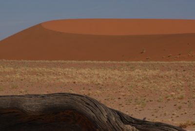
 The coastal desert, the Namib, is nicknamed the Skeleton Coast after whale bones and shipwrecks. Inland lies the great Kalahari Desert and between them lie the lands of two indigenous groups, the Herero and the Nama, where there is a little more rainfall, enough to graze cattle. Here between the deserts the Germans settled their capital, Windhoek, and here they met the indigenous population.
Aggressive German pursuit of lebensraum caused predictable tension leading to a general uprising in 1904. Turns out that, reluctant about the colonizing game as Berlin seemed to be, while they were there they meant to give it a good run.
So the German General Lothar von Trotha, fresh from suppressing the Boxer Rebellion, hit local ground running, declaring that indigenous people “must vanish from the face of the earth.” He issued a vernichtungsbefehl (an extermination order). Von Trotha was running a little hot.
He built a perimeter and starved people in the desert, reducing the Herero from some 80,000 to about 15,000 and halving the Nama population to 10,000. “The natives must give way,” von Trotha declared.
The official military history of the affair declared the local people “victim to the nature of their own country,” but the Socialist opposition decried the ‘Hunnish’ character of German imperialism. The Nazis named a street in Munich after von Trotha, and in 2006 the city council changed its name to Herero Straße.
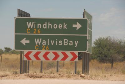 Caprivi’s folly and von Trotha’s brutality stand out as Germany’s most vivid African legacies. Berlin left scant enduring influence in East Africa, but German architecture survives today in the Namibian capital Windhoek, the coastal towns of Lüderitz and Swakopmund and Walvis Bay, and enough German is spoken in Windhoek to support a German-language daily newspaper, the Allgemeine Zeitung Namibia.
•••••
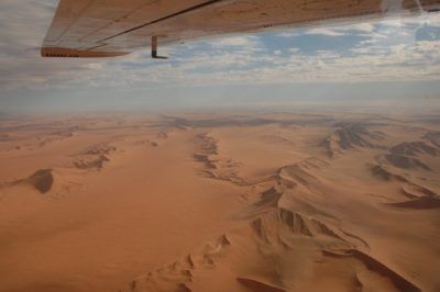
Late in the afternoon a pilot named Lindy, a very, very young woman with blond hair and blazing blue eyes, took three of us up in a Cessna for a trip out over the dunes. She explained that at the coast (55 kilometers away), sometimes they run safaris on the beach, so if we saw any cars we had to let her know immediately!
That was curious. Why?
They could spoil our fun, she grinned. We were required to fly at 3000 feet, but out there she said she would drop us to 500. Where in the world can you flaunt rules like this if not on the desolate coast of bloody Namibia, she wondered. And so we did. I expect everybody does.
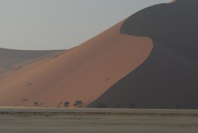 They’ve numbered the dunes by kilometers of distance past the town of Sesriem, and Lindy did a pinwheel around Dune 45, somehow an icon. Our Land Rover had stopped for us to see it, too, that morning, and indeed, folks had been already there and climbing it. Now, just before sundown Dune 45, and all of the dunes, stood deserted. Everyone had to be out of the park at night.
We did another long turn around “Big Daddy,” which local pride boasts as the world’s tallest sand dune (dunes in Iran and Algeria are apparently taller), and in the same sweep took in the striking Deadvlei, a former oasis whose water source changed course, starving its camelthorn trees.
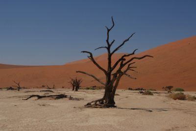 The road ends at Deadvlei and beyond nothing but dunes stretch north to south, horizon to horizon. A curious landscape took hold, orange sand exposed inside low green vegetation in what they called fairy circles. They reckon trees died and somehow poisoned the soil. Nothing grows in the circles, defying intuition about the regenerative power of nature. Somehow in my imagination these were akin to those counterintuitive hexagonal basalt “biscuits” in Northern Ireland’s Giant’s Causeway.
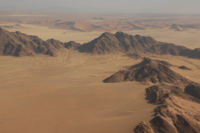
The coast gained focus, and we cruised over a fallen-in diamond mine and the fallen-in settlement around it. The entire idea of it, a man-made place, was jarring, its perpendiculars entirely out of sorts with the natural swirls of the desert that resembled nothing more than crumpled bed sheets.
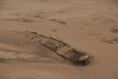 We came down low along the water’s edge over seal colonies, dozens of them that stretched for miles, and over a shipwreck. This was the Eduard Bohlen, now rusted to its remaining rafters, a cargo ship launched from Hamburg some hundred and thirty years ago.
Hamburg’s Woermann Line operated the Bohlen as a mail ship between Germany and West Africa for four years. Then the Bohlen transported Herero prisoners, sold to the Brits in Cape Town as cheap labor. Then it ran aground in fog while supplying equipment to diamond miners.
Though some hundred meters out to sea, the crew could walk to shore at low tide. The ship even remained accessible enough that after a failed attempt to tow it off the sand bar, miners used it as a hotel. The manager claimed the captain’s cabin.
In a hundred twenty years the Bohlen has sailed 400 meters inland. The expansion of the Namib Desert is one more Namibian geographic oddity. The desert is reclaiming the sea.