
Tiago Ventura in Time Magazine:
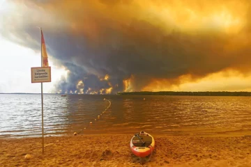 Described by NASA as a “fire-breathing dragon of clouds,” fire clouds are created by the intense heat of wildfires, generating an updraft of superheated, fast-rising air that can trigger powerful storms. Jean-Baptiste Filippi, a researcher at the French National Centre for Scientific Research (CNRS), tells TIME that the clouds fall into two categories: pyrocumulus and pyrocumulonimbus (also known as pyroCb). He explains that pyrocumulus is the first stage of a fire cloud. As the wildfire releases large amounts of heat, the air near the ground heats up and rises rapidly, generating a strong upward current.
“That’s level one, because you’re adding this to the energy of the fire to create the convective column,” he says, referring to a vertical stream of hot, rising gas. As the warm air reaches higher layers of the atmosphere, it cools and expands. When the temperature falls low enough, the water vapor in the air begins to condense, forming a cloud above the smoke column. “Level two is pyrocumulonimbus,” he says. “Imagine now that this energy is enough to overshoot the lower atmosphere and go up to almost the stratosphere.”
More here.
Enjoying the content on 3QD? Help keep us going by donating now.