
by Rebecca Baumgartner
Apsley Cherry-Garrard, the Antarctic explorer who would become famous for documenting Robert Falcon Scott’s expedition in his book The Worst Journey in the World, wrote a letter in 1919 in which he cast doubt on the purity of the motives of one of the expedition members, Lieutenant Edward “Teddy” Evans: “There will…be an unprinted reference to the Antarctic as a white wall upon which some people have a passion for writing their names. If the cap fits let him put it on.”
Photograph by: Elaine Hood/National Science Foundation (NSF) License: Public Domain
One of the fascinating things about Antarctica is how its extreme conditions put the best and worst of humanity into stark relief. From the very beginning, the motives of the people going there have been multi-layered, an adulterated mix of ego, commercial incentive, scientific curiosity, wanderlust, and the siren call of the unknown. Even Cherry-Garrard himself, not having any training or scientific skill to speak of but coming from money, ended up buying his way onto Scott’s team. Geographic landmarks were routinely named after sponsors and backers of various expeditions. The very earliest journeys were motivated entirely by a money-making desire to kill as many seals and whales as possible. One member of Scott’s team was photographed happily eating a tin of Heinz Baked Beans as part of a sponsorship deal. There has never been a time when commercialization wasn’t a major part of the Antarctic enterprise. And it’s likely to stay that way, simply due to the sheer difficulty and expense of getting there in the first place and equipping yourself to survive once there.
In the 130 years since humans first set foot on the continent, the white wall has gotten progressively more filled with names. At one time we had more detailed knowledge of Mars than we did of Antarctica, but no longer. Thanks to the Department of Defense, Antarctica is now the most thoroughly mapped continent on Earth and the people going there today are entering a terra very cognita. The record of firsts has accordingly become more and more contrived. In contrast to the gentleman adventurers of pre-WWI exploration, who often coupled scientific research with more pecuniary goals, the people who go there seeking glory these days are more like NASCAR drivers: heavily funded and sponsored by corporations, equipped with the most technologically advanced gear, and subject to years of specialized training.
The people seeking fame in Antarctica today are also often alone – in fact, many of the only records left to claim are based on a person doing something “unsupported,” a controversial term that highlights the fact that many of these athletes are drawing arbitrary lines around what’s considered support and what’s not. For a group of people obsessed with minimalism in their attempts, it’s strange how they forget that Scott and Shackleton would have undoubtedly considered being flown to the continent a colossal form of support – not to mention the advanced navigational equipment, highly engineered tents and clothing, satellite radios, detailed maps, and well-maintained and crevasse-free highways that all Antarctic explorers use today, even the ones who claim to be “unsupported.”
Photograph by: Joshua Swanson/National Science Foundation (NSF) License: Creative Commons CC BY-NC-ND 4.0
One such case is that of Felicity Aston, a British climatologist who claims to have been the first woman to ski across the entire continent alone, in 2012. She describes the challenges of her 59-day journey in the book Alone in Antarctica, and it’s a useful case study of how narrow and contrived modern Antarctic achievements have become.
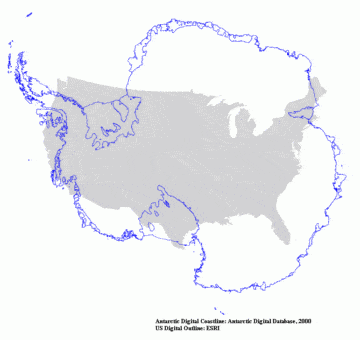
The first thing you notice about Aston’s book is that it does not contain a map. For a claim based entirely on geography, this seems like a particularly strange choice, especially since most readers have no conception of the size or shape of Antarctica. Surely a visual aid would have been immensely helpful. It was such a strange omission that I started wondering about what possible reason Aston or the publishers could have had for leaving it out.
Photograph by: Jessica Walker/National Science Foundation (NSF) License: Creative Commons CC BY-NC-ND 4.0
At the same time, I started wondering how, without kites or sails or vehicles of any kind (she scorned the use of such supports), Aston could have gone across the whole continent in only 59 days. Antarctica is huge – approximately one and a half times the size of the U.S. Is it really feasible that someone could ski across a landmass that size in 59 days using nothing but their leg muscles? The sheer size of the continent, combined with the glaring omission of a map, made me more and more skeptical. I decided to do some digging. This was no easy feat, because even though the continent is thoroughly mapped, it’s next to impossible to find maps showing the particular route that someone took through the region.
When I eventually found such a map, it became obvious that Aston wasn’t being completely honest. In the article containing that map, “Crossing Antarctica: How the Confusion Began and Where Do We Go From Here,” Australian mountaineer and explorer Damien Gildea says that, “For decades, adventurers have manipulated language and withheld information in order to present their journeys in the most flattering light. Using subtle qualifiers that mean something to them and their competitors and not much to anyone else, they sought to gain sponsorship and enhance reputation.”
When the average layperson hears that someone “crossed the continent,” they imagine someone going from the north coast to the south coast, or the west coast to the east coast (or vice versa). But that isn’t even close to what Aston did. Her route looks like a tiny V-shape from one seemingly arbitrary starting point, onward to the South Pole, and finally ending up at another seemingly arbitrary point. Neither her starting point nor her ending point were on the coast, despite her explicitly claiming such in the book. In fact, her route covered a depressingly minuscule portion of the landmass. There is no way of expressing the concept of “across the entire continent” that would make sense of the tiny V-shape she made. And the rationale for those starting and ending points is not geography – it’s simply the most convenient spot for a plane to drop her off and pick her up.
And this is why she chose not to include a map in her book. It would make her distortion of the facts very obvious.
Aston is by no means the only polar explorer engaging in this sort of deception. In fact, it seems to be the norm in that community. It seems they’re banking on the general public’s lack of knowledge about Antarctica – and it’s working. Even major news outlets like the The New York Times take the back-of-the-book blurbs at face value and report on these claims without going to the trouble of verifying that a particular route did indeed go across the continent (which, admittedly, is hard to verify when polar athletes are deliberately vague on the details and decline to publish maps of their routes).
We are justifiably impressed by Aston’s, and all polar explorers’, feats of endurance and physical and psychological strength. Spending two months skiing around Antarctica is, obviously, no walk in the park. These folks should by all means be proud of their athleticism and fortitude. What we should take issue with is the blatant deception about going across the continent – especially the emphasis on being the first to do it, which is tantamount to defining your own route based on what’s most convenient for you and then crowing that no one else had managed to travel that exact route before you, as though their skill or endurance were the limiting factor, and not your own contrivance and mealy-mouthed definitions.
Something else that jumps out from Aston’s narrative is the mega-capitalist enterprise that is polar exploration. This is more than just eating Heinz beans in a parka. Whenever Aston mentioned her tent for any reason throughout the book, she referred to it by its brand name, and always photographed it with the logo visible. I’m assuming these were the conditions of a sponsorship deal in which she got the tent for free. But as with her route, she is not transparent about such details, rightly feeling that such details lessen the impact of her achievement.
Photograph by: Julian Race/National Science Foundation (NSF) License: Creative Commons CC BY-NC-ND 4.0
When someone has a plane drop them off at a convenient starting point, gets free gear, takes an artificially easy route, receives fresh fruit and homemade cookies at the South Pole, posts on Twitter every night, and gets picked up by a plane wherever they’ve decided to stop, as Aston did, it’s hard to see their journey as anything other than a vanity project, full of artificial safety nets and a lot of self-promotion. As Gildea put it:
“Paying hundreds of thousands of dollars to force ourselves to demonstrate how tough we are can seem like some game for the bored and affluent. One can only make such choices from a position of luck and privilege, and such resources might be put to better use than dragging your snacks across the snow for a couple of months while quoting Shackleton on Instagram.”
If the cap fits let him put it on.