
Robert Macfarlane, Frances Hardinge and Miraphora Mina at The Guardian:
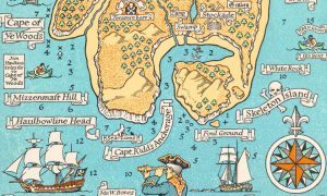 In the beginning was the map. Robert Louis Stevenson drew it in the summer of 1881 to entertain his 12-year-old stepson, Lloyd Osbourne, while on a rainy family holiday in Scotland. It depicts a rough-coasted island of woods, peaks, swamps and coves. A few place names are marked, which speak of adventure and disaster: Spyeglass Hill, Graves, Skeleton Island. The penmanship is deft, confident – at the island’s southern end is an intricate compass rose, and the sketch of a galleon at full sail. Figures signal the depth in fathoms of the surrounding sea, and there are warnings to mariners: “Strong tide here”, “Foul ground”. In the heart of the island is a blood-red cross, by which is scrawled the legend “Bulk of treasure here”.
Stevenson’s map was drawn to set a child dreaming, but it worked most powerfully on its grownup author, inspiring him to write his great pirate novel, Treasure Island.
more here.